000
FXUS62 KMLB 042004
AFDMLB
Area Forecast Discussion
National Weather Service Melbourne FL
404 PM EDT Thu Nov 4 2021
.DISCUSSION...
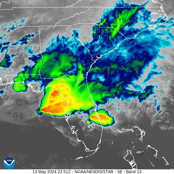
...Active Weather Arriving Tonight into Friday Night with Locally
Heavy Rainfall and Strong Storms Possible...
...Coastal Flooding and Minor Beach Erosion Possible Friday
Through at Least Sunday...
Evening/Tonight...A digging upper-level trough will move across the
Gulf of Mexico and develop a surface low pressure that will approach
FL during the day Friday. Higher moisture will overspread central
Florida from north to south, and increasing coastal convergence and
onshore flow as the gradient tightens will result in high
coverage of showers and storms over the Atlantic and across the
coastal counties. There is some potential for locally heavy
rainfall for any persistent bands of showers and storms tonight
along the coast with hi-res guidance suggesting Brevard and
Volusia have the higher chance of this occurring. Some shortwave
energy passing overhead may also develop some showers and possibly
a storm across inland areas. Rain chances 70% along the coast and
50-60% across the interior. Overnight lows in the mid-upper 60s.
Fri-Sat (modified previous)...Wet and unsettled pattern expected
Friday into Friday night, as low pressure pushes eastward across the
FL peninsula along a stalled front near to just north of Lake
Okeechobee. Strengthening mid-upper level trough/closed low moving
through the Southeast U.S. will deepen this low pressure at the sfc
as it shifts just offshore the east central Florida coast late
Friday night into early weekend. This will lead to increasing
northerly winds producing breezy/windy conditions across much of
east central FL into Saturday.
Overrunning moisture along and north of the front combined with
passing sfc low and advancing trough aloft will lead to high
rainfall coverage across the area Friday into Friday night, with
PoPs around 80-90 percent on Friday and up to 60-80 percent on
Friday night. While overall instability remains rather low,
increasing shear and cold temps aloft (around -10 to -11C at 500mb)
may allow for some embedded storm development. Some storms could
become strong, mainly near to south of the front toward Okeechobee
County and the Treasure Coast during the afternoon and evening hours
on Friday, especially with the latest models trending a little
farther north with this surface low. However, the primary threat
will be locally heavy rainfall from Friday morning into Friday
night, especially along the coast and moreso toward Volusia and
Brevard counties. A Flood Watch has been issued for Brevard/Volusia
where rainfall amounts of 3-4 inches are possible with locally
higher amounts of up to 6 inches. Drier mid-level air will then move
in from the west into Saturday, focusing highest rain chances up to
50-60 percent toward the coast.
Increased cloud cover/rainfall on Friday and increasing northerly
winds on Saturday will keep highs in the 70s for much of the area
each day. Overnight lows will fall into the 60s Friday night with
even cooler min temps in the 50s to low 60s expected into Saturday
night.

This is supposed to be the dry season.
FXUS62 KMLB 042004
AFDMLB
Area Forecast Discussion
National Weather Service Melbourne FL
404 PM EDT Thu Nov 4 2021
.DISCUSSION...
...Active Weather Arriving Tonight into Friday Night with Locally
Heavy Rainfall and Strong Storms Possible...
...Coastal Flooding and Minor Beach Erosion Possible Friday
Through at Least Sunday...
Evening/Tonight...A digging upper-level trough will move across the
Gulf of Mexico and develop a surface low pressure that will approach
FL during the day Friday. Higher moisture will overspread central
Florida from north to south, and increasing coastal convergence and
onshore flow as the gradient tightens will result in high
coverage of showers and storms over the Atlantic and across the
coastal counties. There is some potential for locally heavy
rainfall for any persistent bands of showers and storms tonight
along the coast with hi-res guidance suggesting Brevard and
Volusia have the higher chance of this occurring. Some shortwave
energy passing overhead may also develop some showers and possibly
a storm across inland areas. Rain chances 70% along the coast and
50-60% across the interior. Overnight lows in the mid-upper 60s.
Fri-Sat (modified previous)...Wet and unsettled pattern expected
Friday into Friday night, as low pressure pushes eastward across the
FL peninsula along a stalled front near to just north of Lake
Okeechobee. Strengthening mid-upper level trough/closed low moving
through the Southeast U.S. will deepen this low pressure at the sfc
as it shifts just offshore the east central Florida coast late
Friday night into early weekend. This will lead to increasing
northerly winds producing breezy/windy conditions across much of
east central FL into Saturday.
Overrunning moisture along and north of the front combined with
passing sfc low and advancing trough aloft will lead to high
rainfall coverage across the area Friday into Friday night, with
PoPs around 80-90 percent on Friday and up to 60-80 percent on
Friday night. While overall instability remains rather low,
increasing shear and cold temps aloft (around -10 to -11C at 500mb)
may allow for some embedded storm development. Some storms could
become strong, mainly near to south of the front toward Okeechobee
County and the Treasure Coast during the afternoon and evening hours
on Friday, especially with the latest models trending a little
farther north with this surface low. However, the primary threat
will be locally heavy rainfall from Friday morning into Friday
night, especially along the coast and moreso toward Volusia and
Brevard counties. A Flood Watch has been issued for Brevard/Volusia
where rainfall amounts of 3-4 inches are possible with locally
higher amounts of up to 6 inches. Drier mid-level air will then move
in from the west into Saturday, focusing highest rain chances up to
50-60 percent toward the coast.
Increased cloud cover/rainfall on Friday and increasing northerly
winds on Saturday will keep highs in the 70s for much of the area
each day. Overnight lows will fall into the 60s Friday night with
even cooler min temps in the 50s to low 60s expected into Saturday
night.
This is supposed to be the dry season.