ADVERTISEMENT

AccuWeather RealFeel temps to top 100 degrees for 160M at height of heat wave

Dec 31, 2014
17,738
29,293
113
“A dangerous and extended heat wave with 90-degree heat is gripping the northeastern United States as if right on cue for the dog days of summer. Record-challenging heat will not only persist straight through the weekend in major cities up and down the Eastern Seaboard, but temperatures may also climb to levels that haven’t been felt for 10 years in some locations, AccuWeather meteorologists warn.

By Sunday, some 160 million Americans are expected to experience an AccuWeather RealFeel® Temperature of 100 degrees or higher, the AccuWeather forecasting team cautioned.”


NEHeat720.jpg


TXheatstats720.jpg
 
OMG! OMG! OMG!

It’s July. It gets hot in July. 1930s. Cyclical. Relax.

That, or weather modification.

Either way, I just want to know who I can give all my money to in order to prevent climate change so my kids’ kids’ kids’ kids’ kids’ don’t have to put up with 91 degrees instead of 89.

Oh, and I also hope all my money makes it possible for certain people to be able to afford that 6th house and 4th private jet. I just want to help.
 
Playing in golf tournament here in Newton tomorrow, Tee time is 1:00, temp in 90’s, It’s summertime, Perfect golf weather!
 
OMG! OMG! OMG!

It’s July. It gets hot in July. 1930s. Cyclical. Relax.

That, or weather modification.

Either way, I just want to know who I can give all my money to in order to prevent climate change so my kids’ kids’ kids’ kids’ kids’ don’t have to put up with 91 degrees instead of 89.

Oh, and I also hope all my money makes it possible for certain people to be able to afford that 6th house and 4th private jet. I just want to help.
You seem to have it all figured out.
 
If it was Christmas....or Halloween even, I might be concerned.

Get a grip. It’s summer.

The biggest concern is very high temps in areas where >90% of the homes don't have central AC. For instance, my brother lives in Bozeman, MT and he only has 1 window unit in his bedroom for a ~2500 sq ft house. Another concern would be the strain on the power grid in places like Texas (where everyone has central AC). "It's summer so it's supposed to be hot" is an overly simplistic mindset.
 
Is it hot and humid in Iowa in the summer? If corn didn't like it do you think farmers would spend all that time and money planting it here?

In Florida, we plant corn in January so that's it's ready by May before it gets insanely hot, muggy and buggy.
 
It's almost like the extra layer of fat that most Americans carry isn't going to make them comfortable in this weather
 
If it was Christmas....or Halloween even, I might be concerned.

Get a grip. It’s summer.
Since Christmas is in December, were/are you concerned about the derecho which hit Iowa last December and produced 43 tornadoes with record high temperatures across the state?

Iowa's second derecho in two years spawned 43 tornadoes. Here's how the storm compared to others​

Officials have determined at least 43 tornadoes resulted from the Dec. 15 derecho that swept across Iowa — more than seven times the total number of tornadoes to take shape in December in Iowa since 1950, and the most tornadoes in any single day in the state's historical record.
As data from last week's storm — the first December derecho in U.S. history — continues to be processed, its historic nature becomes clearer. The storm will go down as the worst late-fall or winter thunderstorm in Iowa's recorded history, said Mike Fowle, the science and operations officer at the National Weather Service in Des Moines. It could also rank as one of the worst severe thunderstorms ever recorded in Iowa, regardless of season, he said.
Between 1950 and 2020, only six tornadoes were ever recorded in December in Iowa, according to the NWS. All of them were recorded in southeastern Iowa. Of Dec. 15's 43, 17 were identified as EF2s, with wind gusts of at least 111 mph.

Iowa's previous single-day record of 35 tornadoes was set on Aug. 31, 2014. And meteorologists with the NWS say more tornadoes resulting from the Dec. 15 storm could still be confirmed.
"In the modern era, we haven't seen anything like this in at least the last 75 years," Fowle said. "This is going to be in the upper-echelon of events — anytime you talk 'historic,' you talk the top 5-10% of events."

Iowa wasn't alone in seeing action on Dec. 15: At least 92 tornadoes have been confirmed across Nebraska, Iowa, Minnesota and Wisconsin, according to the NWS. Twenty-seven were confirmed in Nebraska alone.
Meteorologists say a perfect mix created a cocktail ready to produce severe thunderstorms and tornadoes that day. Warm air from the Gulf of Mexico met a powerful low-pressure system as it raced from the central Rocky Mountains, northeast through the Plains and into the Great Lakes, said Peter Rogers, a meteorologist at the NWS in Sioux Falls, South Dakota. Normally in the late fall, warm air from the Gulf of Mexico meets with cold air in the Midwest, reducing the chances for thunderstorms, according to the weather service's storm prediction center.
Des Moines and Waterloo both smashed high-temperature records on Dec. 15, too, with highs of 74 degrees, which handily beat the cities' previous records of 69 and 67 degrees, respectively. Oskaloosa, Muscatine, Iowa City and Ottumwa all set a new record high for the month in Iowa — which was 74 degrees, set on Dec. 6, 1939, in southwest Iowa's Thurman — with highs of 75 degrees.
"Warmer air can hold more moisture, and the more moisture you have available has the potential to increase the severity of storms," Rogers said. "All of that came together at a very odd time of year."
Numerous agricultural buildings sustained severe damage last week, according to damage reports. Vehicles were overturned and some houses had their roofs taken off. Numerous trees and power lines were also damaged.
A tornado hit the middle of Rudd, in the state's northeast corner, heavily damaging a church and library. The tornado that hit Aurelia, in northwest Iowa, caused the most damage out of the 10 in that corner of the state when it tipped over rail cars, collapsed a hog barn and caused other damage, Rogers said.

But population centers like Council Bluffs, Carroll and Sioux City narrowly escaped significant damage. A tornado was confirmed in Sergeant Bluff, just south of Sioux City, and tornadoes touched down on opposite ends of Jefferson, Fowle said; a tornado also landed just west of Atlantic and another clipped a corner of Grand Junction, he said.
No fatalities or injuries were recorded from any of the touchdowns in Iowa, a fact that has astonished meteorologists, although a semitrailer driver was killed in Benton County, west of Cedar Rapids, when a non-tornadic gust of wind hit his truck and caused it to roll over. In total, five deaths were blamed on the derecho across all states.
Many of the tornadoes were narrow, which minimized the destruction, Fowle said. But there were also several long tornadoes: Four were on the ground for more than 20 miles, the longest being an EF2 tornado that hit Belmond and Meservey and was on the ground for 28 miles. Eleven were on the ground for more than 10 miles.
A tornado approaches Interstate 80 near Atlantic, Iowa, as a semi rolls eastward on Wednesday, Dec. 15, 2021. This tornado was an EF2 tornado, was on the ground for 26.1 miles had peak wind speeds of 115 to 120 mph.


"Thankfully, the footprint of these towns is fairly small," Fowle said. "In our forecast area, we pretty much missed a direct hit on any town."
Since 1950, the number of days in which tornadoes form across Iowa has diminished, State Climatologist Justin Glisan said. But days with tornado outbreaks are increasing, Glisan said.
On July 14, 26 tornadoes hit Iowa in what was, at the time, the third-largest single-day tornado outbreak since record-keeping began. Iowa had "basically a lack of severe weather" outside these two storms, Glisan said.
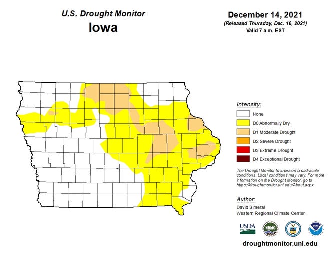
Thunderstorms are an important source of precipitation. Yet most of Iowa was mired in a drought for the second straight year.
"That's reflected in the drought conditions," Glisan said. "No thunderstorms. No rainfall."
Parts of eastern Iowa are still considered to be in moderate droughts.


Two derechos in two years​

Forecasters expect Iowa to get hit by a derecho once every two years, Glisan said. Prior to last year's derecho, the last to hit the state was in 2014. A total of 13 derechos have been recorded in Iowa since 1980, Glisan said.
"To have derechos within two years of this intensity" is rare, he confirmed.

Last August's derecho traveled 770 miles as straight-line winds decimated crops and shattered homes in Iowa, Illinois, Ohio, Minnesota and Wisconsin. It caused more than $11.5 billion in damage. To date, it is still the most costly thunderstorm in U.S. history.
Last week's serial derecho, a type of derecho produced by thunderstorms with strong winds which bow outward, traveled at least 550 miles through Kansas, Nebraska, Missouri, Minnesota, Iowa and Wisconsin, Fowle said.
The 2020 derecho was a progressive derecho, a type of storm fueled by a hot and moist environment with relatively strong winds. Serial derechos typically sweep across wide and long paths. Progressive derechos are typically associated with shorter lines of thunderstorms that travel along narrower paths.
The 2020 derecho was stronger than the Dec. 15 event, producing peak wind gusts of around 140 mph. The strongest gust recorded last week was 88 mph in Audubon.
But winds not associated with thunderstorms — behind this system — were stronger, Glisan said.
"If you drew a line from the southwest corner through the northeast corner, all the tornado warnings and tornado reports were northwest of that line," he said.
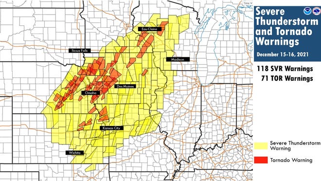
There were 118 severe thunderstorm and 71 tornado warnings across Oklahoma, Kansas, Nebraska, Missouri, Wisconsin, Illinois and Iowa from a powerful thunderstorm system on Wed. Dec. 15, 2021 and Thurs. Dec. 16, 2021.


As the front moved across Iowa, it started to bow out in the southern part of the state. The tornados all happened north of that bowing and spared the southeast part of the state, Glisan said.
"Basically, the line had storm motion to the northeast, Glisan said. "You had very strong ambient large-scale winds out of the south, so you had friction along that line and that's where you get those spin-up tornadoes."

'We're seeing these conditions co-mingle'​

Southeast Iowa was forecast to see above-average temperatures this winter because this is the second straight winter with a La Nina weather pattern, or a natural cooling of sea water in the Pacific Ocean. La Ninas favor warmer-than-average temperatures and below-average precipitation in the southeastern U.S., and colder-than-average temperatures and above-average precipitation in the northwest.
But as the climate warms, extreme weather is happening more often in Iowa, Glisan said. The number of days with environments conducive for making severe weather are increasing because more water vapor is available, he said.

In recent years, Iowa has seen flooding caused by higher-intensity rainfall coupled simultaneously with or in years opposite of droughts. While 2018 was the second-wettest year in 149 years of record-keeping, for example, a drought also gripped southeastern Iowa.
"We're seeing these conditions co-mingle," Glisan said.

The Dec. 15 outbreak followed another late on Dec. 10 and early on Dec. 11 that swept across Missouri, Arkansas, Tennessee, Kentucky and Illinois and killed 91 people, according to USA TODAY. An EF4 tornado with wind speeds of 190 mph and more than a mile wide traveled on the ground for 166 miles, decimating Mayfield, Kentucky. Another EF3 tornado with winds of 160 mph in the same system was on the ground for 123 miles.
"I would greatly take these types of tornadoes (seen in Iowa on Dec. 15) versus the supercells on the Dec. 10 event," Glisan said. "Those long-track supercells are scary, scary things."
The two systems were the result of four "heat pulses" to hit the U.S. this month, according to Matthew Cappucci, a meteorologist for the Washington Post. Record highs were set in four states during the first pulse, on Dec. 1 and 2. The fourth is expected to settle across the southwest U.S. on Friday, according to Cappucci.
Friday and Saturday's highs in Des Moines, expected to be 54 and 43 degrees, respectively, would be well above the average high of 33 degrees for Dec. 24 and Dec. 25.

"It reinforces the connection between human-induced climate change and the incidence of warm temperatures in the wintertime," Cappucci wrote. "Heat extremes have outpaced cold records at a rate greater than 2 to 1 this year, and the holidays are a time of year when that warming is especially pronounced."
Eventually, Des Moines is expected to see the more typical cold and snowy weather associated with the season, Glisan said.
"February is becoming the problem child month," Glisan said. "We get those cold-air outbreaks, but also higher snow potential."

https://www.desmoinesregister.com/s...oric-december-serial-derecho-2021/8995299002/
 
Since Christmas is in December, were/are you concerned about the derecho which hit Iowa last December and produced 43 tornadoes with record high temperatures across the state?

Iowa's second derecho in two years spawned 43 tornadoes. Here's how the storm compared to others​

Officials have determined at least 43 tornadoes resulted from the Dec. 15 derecho that swept across Iowa — more than seven times the total number of tornadoes to take shape in December in Iowa since 1950, and the most tornadoes in any single day in the state's historical record.
As data from last week's storm — the first December derecho in U.S. history — continues to be processed, its historic nature becomes clearer. The storm will go down as the worst late-fall or winter thunderstorm in Iowa's recorded history, said Mike Fowle, the science and operations officer at the National Weather Service in Des Moines. It could also rank as one of the worst severe thunderstorms ever recorded in Iowa, regardless of season, he said.
Between 1950 and 2020, only six tornadoes were ever recorded in December in Iowa, according to the NWS. All of them were recorded in southeastern Iowa. Of Dec. 15's 43, 17 were identified as EF2s, with wind gusts of at least 111 mph.

Iowa's previous single-day record of 35 tornadoes was set on Aug. 31, 2014. And meteorologists with the NWS say more tornadoes resulting from the Dec. 15 storm could still be confirmed.
"In the modern era, we haven't seen anything like this in at least the last 75 years," Fowle said. "This is going to be in the upper-echelon of events — anytime you talk 'historic,' you talk the top 5-10% of events."

Iowa wasn't alone in seeing action on Dec. 15: At least 92 tornadoes have been confirmed across Nebraska, Iowa, Minnesota and Wisconsin, according to the NWS. Twenty-seven were confirmed in Nebraska alone.
Meteorologists say a perfect mix created a cocktail ready to produce severe thunderstorms and tornadoes that day. Warm air from the Gulf of Mexico met a powerful low-pressure system as it raced from the central Rocky Mountains, northeast through the Plains and into the Great Lakes, said Peter Rogers, a meteorologist at the NWS in Sioux Falls, South Dakota. Normally in the late fall, warm air from the Gulf of Mexico meets with cold air in the Midwest, reducing the chances for thunderstorms, according to the weather service's storm prediction center.
Des Moines and Waterloo both smashed high-temperature records on Dec. 15, too, with highs of 74 degrees, which handily beat the cities' previous records of 69 and 67 degrees, respectively. Oskaloosa, Muscatine, Iowa City and Ottumwa all set a new record high for the month in Iowa — which was 74 degrees, set on Dec. 6, 1939, in southwest Iowa's Thurman — with highs of 75 degrees.
"Warmer air can hold more moisture, and the more moisture you have available has the potential to increase the severity of storms," Rogers said. "All of that came together at a very odd time of year."
Numerous agricultural buildings sustained severe damage last week, according to damage reports. Vehicles were overturned and some houses had their roofs taken off. Numerous trees and power lines were also damaged.
A tornado hit the middle of Rudd, in the state's northeast corner, heavily damaging a church and library. The tornado that hit Aurelia, in northwest Iowa, caused the most damage out of the 10 in that corner of the state when it tipped over rail cars, collapsed a hog barn and caused other damage, Rogers said.

But population centers like Council Bluffs, Carroll and Sioux City narrowly escaped significant damage. A tornado was confirmed in Sergeant Bluff, just south of Sioux City, and tornadoes touched down on opposite ends of Jefferson, Fowle said; a tornado also landed just west of Atlantic and another clipped a corner of Grand Junction, he said.
No fatalities or injuries were recorded from any of the touchdowns in Iowa, a fact that has astonished meteorologists, although a semitrailer driver was killed in Benton County, west of Cedar Rapids, when a non-tornadic gust of wind hit his truck and caused it to roll over. In total, five deaths were blamed on the derecho across all states.
Many of the tornadoes were narrow, which minimized the destruction, Fowle said. But there were also several long tornadoes: Four were on the ground for more than 20 miles, the longest being an EF2 tornado that hit Belmond and Meservey and was on the ground for 28 miles. Eleven were on the ground for more than 10 miles.
A tornado approaches Interstate 80 near Atlantic, Iowa, as a semi rolls eastward on Wednesday, Dec. 15, 2021. This tornado was an EF2 tornado, was on the ground for 26.1 miles had peak wind speeds of 115 to 120 mph.


"Thankfully, the footprint of these towns is fairly small," Fowle said. "In our forecast area, we pretty much missed a direct hit on any town."
Since 1950, the number of days in which tornadoes form across Iowa has diminished, State Climatologist Justin Glisan said. But days with tornado outbreaks are increasing, Glisan said.
On July 14, 26 tornadoes hit Iowa in what was, at the time, the third-largest single-day tornado outbreak since record-keeping began. Iowa had "basically a lack of severe weather" outside these two storms, Glisan said.
Thunderstorms are an important source of precipitation. Yet most of Iowa was mired in a drought for the second straight year.
"That's reflected in the drought conditions," Glisan said. "No thunderstorms. No rainfall."
Parts of eastern Iowa are still considered to be in moderate droughts.


Was/am I concerned? No.
 
ADVERTISEMENT
ADVERTISEMENT