ADVERTISEMENT

***OFFICIAL 2023 FLOOD THREAD***

torbee

HR King
Gold Member
It's been a little annoying to have the temps stay stubbornly cool --- but above freezing days and below freezing nights is helping the snowpack up north melt relatively slowly, which is helping bring flood risk down.

National Weather Service releases additional flood outlook​

The flood risk on the Mississippi River remains above normal, but we did see a decrease in major flood potential.


National Weather Service releases additional flood outlook


Author: Morgan Strackbein
Published: 4:32 PM CDT March 23, 2023
Updated: 6:05 PM CDT March 23, 2023

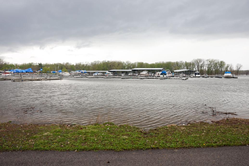
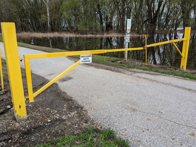
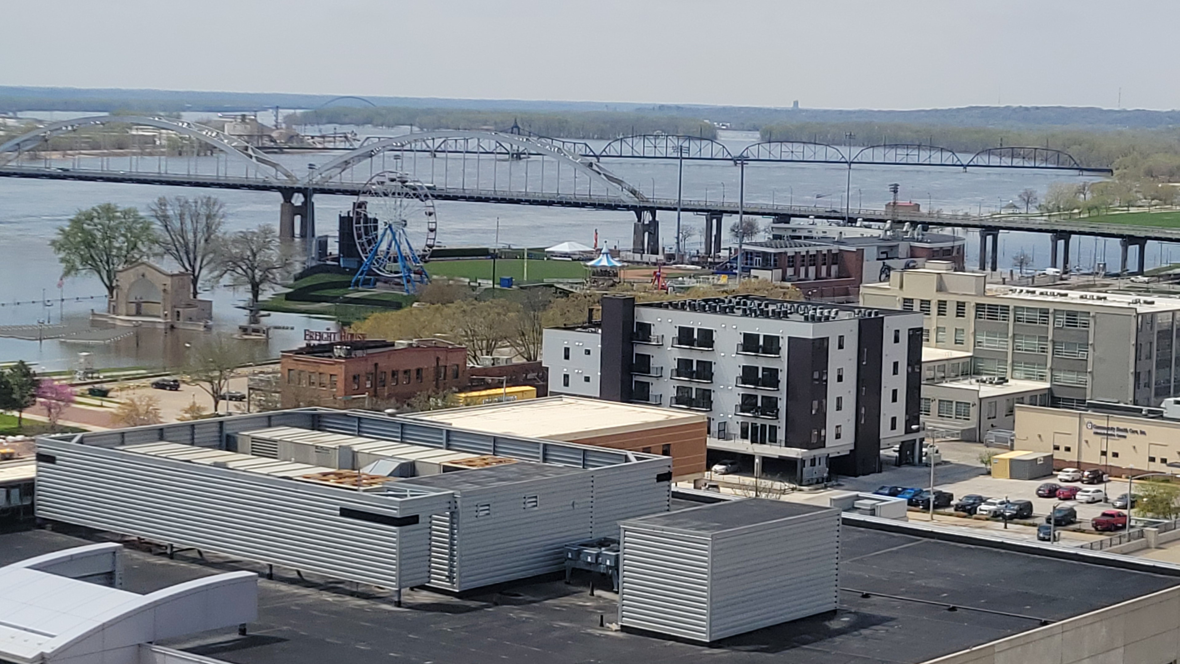
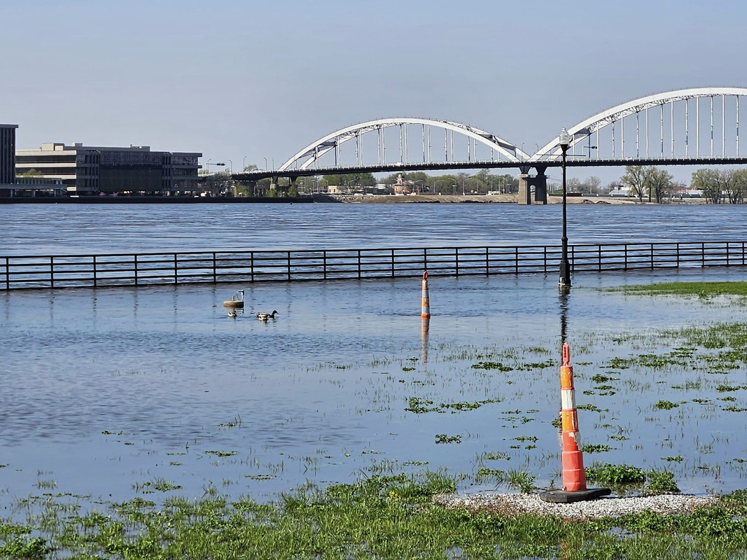
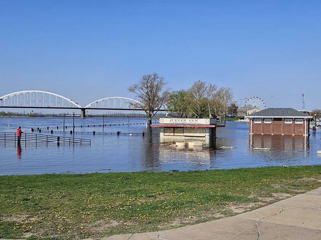
MOLINE, Ill. — The National Weather Service has released a fourth update on the river flood potential. While the flood risk on the Mississippi River remains above normal, there is some good news with the potential of reaching major flood stage.

Two weeks ago, the probability of reaching major flood state on the Mississippi River at Rock Island was 82%. On Thursday, that probability dropped to 68%.

The reason we have seen this slight decrease is due to drier-than-usual conditions locally and to our north during the past two weeks. This means that the streamflow in the upper Mississippi basin is running near normal and is able to take on a little extra water.

Reaching minor and moderate flood stages still remains high at a 95%+ chance as there is still a heavy snowpack on the ground to the north in Minnesota and Wisconsin. The rate of snowmelt, additional snowfall and spring rains will still be monitored closely to determine the severity of the flood risk going forward.
Interested in when we could see river levels peak this year? That looks to be around the end of April and the first week of May as of Thursday's update. If we see temperatures cooler than normal into the month of April, then that timeline could be shifted later.

The National Weather Service will continue to release outlooks throughout the next few months. You can find those future outlooks here.

Here's a quick summary of other rivers throughout the Quad Cities and the associated flood risk for the period of March 27 to June 25:

Rock River near Moline & Joslin - Probability of meeting or exceeding the following stages:
  • Minor: 65%
  • Moderate: 45%
  • Major: 30%
Wapsipinicon River near DeWitt - Probability of meeting or exceeding the following stages:
  • Minor: 82%
  • Moderate: 76%
  • Major: 49%
Cedar River near Conesville - Probability of meeting or exceeding the following stages:
  • Minor: 61%
  • Moderate: 16%
  • Major: 6%
 
  • Like
Reactions: Colonoscopy
Well...the thinking in late March is beginning to wear off because it looks like the river is going to go pretty damn high now. Looks like today they've upgraded most all the L&D cities from moderate to major flooding possible along the entire state.

There isn't one single NWS product that gives a good overall picture, so the link here - just look for the purple.

We can blame the recent quickie snow melt from last week, plus the far up north melt that really hasn't gotten going much yet - then the recent heavy snows up north since this came out on 3/24 along with the rains that appear to be coming with the system later this week.

Add it all up - the Mississippi is probably going to go big the next few weeks unfortunately.

ahhh, crap
 
  • Wow
Reactions: h-hawk
Well...the thinking in late March is beginning to wear off because it looks like the river is going to go pretty damn high now. Looks like today they've upgraded most all the L&D cities from moderate to major flooding possible along the entire state.

There isn't one single NWS product that gives a good overall picture, so the link here - just look for the purple.

We can blame the recent quickie snow melt from last week, plus the far up north melt that really hasn't gotten going much yet - then the recent heavy snows up north since this came out on 3/24 along with the rains that appear to be coming with the system later this week.

Add it all up - the Mississippi is probably going to go big the next few weeks unfortunately.

ahhh, crap
Yeah, it's going to be "major" flood. Hopefully stays under 20 feet (that is when shit gets dicey for downtown Davenport and Moline)

My wife's headquarters building is already starting to get stormwater backup water in the back 40.
 
  • Wow
Reactions: hawkdave007
"The N Stew" on YT had a video come out this morning about spring flooding. It was very general - but one thing stuck out.

I believe it was Minneapolis, they had only 2 inches under the record for seasonal snow. Something like 89". MN and western WI got crushed with snow this past winter (and that still might not be over yet). The good news (if there is any) is that the short term forecast past this week is for not too much rain. Let's hope that turns out true because any appreciable rains up north and things could get really bad.

I saw Nick's video posted this morning - he must have known the new (ominous) hydrology forecasts were coming. Seems like today the NWS went all defcon 2 on the Mississippi.
 
Moved everything up at the kid's place in Guttenberg last weekend. Slow Joe winters has it at 14.5 today and going to 18.5 next Monday. New furnace and water heater hang from the rafters. Hope it doesn't get that high. This is the first flood since he owned it, so we'll see...

He must live in The Island. I know a friend of mine was doing the exact same thing - he built his place up there to more or less withstand a 20 foot crest without anything major getting affected.

He's not too sure he's going to be safe. 20 feet is certainly doable this year. One other good thing is we're going to get a major cold snap (for late April) to close out the month. That should slow the melt up north some.

My place will be fine. It'd have to get above the railroad embankment to reach my place and that happened only once in 1965 and my place still had a few feet to spare.
 
  • Like
Reactions: jamesvanderwulf
Looks like Lansing will top out at 18' ( I hope) which means it will be to the bottom step at our place. Heading up Thursday to move stuff stored below.
 
He must live in The Island. I know a friend of mine was doing the exact same thing - he built his place up there to more or less withstand a 20 foot crest without anything major getting affected.
Yep. We gutted the place down to the studs over the previous winter, so everything is new upstairs. New HVAC, drywall, windows, cabinetry, everything. On newer raised block foundation. The unattached garage will certainly flood, his dock is out and chained to a tree...
 
  • Like
Reactions: h-hawk
Yep. We gutted the place down to the studs over the previous winter, so everything is new upstairs. New HVAC, drywall, windows, cabinetry, everything. On newer raised block foundation. The unattached garage will certainly flood, his dock is out and chained to a tree...
Good luck!

Floods suck.
 
  • Like
Reactions: jamesvanderwulf
Jebus, Guttenberg L&D 10 expected to go above 20 next week and they're now saying it's possible it may hit 2001 levels. For perspective, in 2001 Guttenberg got to 21.68 ft on 4/21/2001 (22 yrs ago today) and that's the 2nd highest crest on record.

It's going to be June before the river drops back to a reasonable level. Maybe. One thing I've learned is it rises quickly, but drops ever so slowly.
 
The Mississippi was at all time lows the last couple of years correct? Hopefully, this will get it back to normal levels after it comes back down.

Last late summer and fall it got really low in certain parts. That occurred because up north was in severe drought.

Near record to record snows there this winter - then a rapid late winter melt combined with more heavy snows and rain, and voila...
 
  • Like
Reactions: Hawkman98
Jebus, Guttenberg L&D 10 expected to go above 20 next week and they're now saying it's possible it may hit 2001 levels. For perspective, in 2001 Guttenberg got to 21.68 ft on 4/21/2001 (22 yrs ago today) and that's the 2nd highest crest on record.

It's going to be June before the river drops back to a reasonable level. Maybe. One thing I've learned is it rises quickly, but drops ever so slowly.
A lot of trees and logs going to be floating around….once you can boat again be on the lookout….
 
A lot of trees and logs going to be floating around….once you can boat again be on the lookout….

Last time I was up was 2 weekends ago there were whole trees floating by roughly every 30 minutes, and the levels were in the 12's. Trees big enough that barges have to dodge them.

When I go up tomorrow (probably 17's by then) there'll be a whole damn forest floating by my cabin.
 
A lot of trees and logs going to be floating around….once you can boat again be on the lookout….
Rode my bike home from work yesterday along river and saw pallets, pieces of dock, large trees and all kinds of nasty crap already coming down.

This is going to be a bad one again.

Looking like our fifth "100-year-flood" within the last 15 years. Climate change is real, people.


Here are the Top 10 Mississippi River crests at Locks and Dam 15, according to the National Weather Service in Davenport. Flood stage is 15 feet.

1. 22.70 feet, May 2, 2019
2. 22.63 feet, July 9, 1993
3. 22.48 feet, April 28, 1965
4. 22.33 feet, April 25, 2001
5. 22.00 feet, March 10, 1868
6. 21.68 feet, June 2, 2019
7. 21.49 feet, June 16, 2008
8. 20.90 feet, July 4, 2014
9. 20.71 feet, April 23, 2011
10. 20.68 feet, April 7, 2019
Bonus
19.66 feet, April 20, 1997
19.40 feet, June 27, 1892
19.30 feet, April 26, 1969
19.24 feet, April 29, 2008

 
  • Like
Reactions: BelemNole
Rode my bike home from work yesterday along river and saw pallets, pieces of dock, large trees and all kinds of nasty crap already coming down.

This is going to be a bad one again.

Looking like our fifth "100-year-flood" within the last 15 years. Climate change is real, people.


Here are the Top 10 Mississippi River crests at Locks and Dam 15, according to the National Weather Service in Davenport. Flood stage is 15 feet.

1. 22.70 feet, May 2, 2019
2. 22.63 feet, July 9, 1993
3. 22.48 feet, April 28, 1965
4. 22.33 feet, April 25, 2001
5. 22.00 feet, March 10, 1868
6. 21.68 feet, June 2, 2019
7. 21.49 feet, June 16, 2008
8. 20.90 feet, July 4, 2014
9. 20.71 feet, April 23, 2011
10. 20.68 feet, April 7, 2019
Bonus
19.66 feet, April 20, 1997
19.40 feet, June 27, 1892
19.30 feet, April 26, 1969
19.24 feet, April 29, 2008

My no pic sister’s family has a cabin on Abel Island in Guttenberg and she was on the phone yesterday trying to get the propane company to come get their leased propane tank so there isn’t a torpedo floating down the river…I also have some friends with homes on lake Delhi. This high water on the Mississippi will force boater’s off the mighty muddy and they will go to Delhi instead. Delhi is long and narrow and already busy. It will be a busy mess this summer…
 
  • Like
Reactions: h-hawk
3rd street is one lane and now River Drive is closed.. traffic should be fun

HESCO works great. Hopefully the city listens to the Army this time and doubles it up in the trouble area by the Government Bridge

For me, I'm just out of water range.. 2019 the flood was about a half a block away from me /csb
 
  • Like
Reactions: h-hawk and torbee
3rd street is one lane and now River Drive is closed.. traffic should be fun

HESCO works great. Hopefully the city listens to the Army this time and doubles it up in the trouble area by the Government Bridge

For me, I'm just out of water range.. 2019 the flood was about a half a block away from me /csb
So the SBW's company HQ is not far from the river and I currently am storing the Toona Schoona in the Back 40. Was supposed to put it in lake last weekend, but the only day that worked was Sunday and I didn't want to put it in during 40 mph wind and snow squalls. But now I'm a little worried about it floating away!!!!
 
Hot off the email presses:

Importance: High


RiverGageRiver StatusCurrent StageCrest Stage (Current Official 7-day Prediction)Crest Date (Current Official 7-day Prediction)Stage Category (Current Official 7-day Prediction)Record StageMost Recent Top 10 EventSnowmelt +/- 1' (NWS 4/20 Briefing Data)
MississippiCamancheRising
18.96​
23.0
30-Apr​
Major
24.6​
22.77 - 5/1/1923.0 (22.0-24.0 range)
MississippiLe ClaireRising
12.07​
15.6+
30-Apr​
Major
17.8​
16.5 - 5/2/1916.5 (15.5-17.5 range)
MississippiRock IslandRising
17.7​
21.1+
30-Apr​
Major
22.7​
22.7 - 5/2/1922.0 (21.0-23.0 range)
MississippiIllinois CityRising
16.05​
20.6+
30-Apr​
Major
24.1​
23.23 - 5/3/1922.0 (21.0-23.0 range)
MississippiMuscatineRising
17.43​
22+
30-Apr​
Major
25.6​
24.52 - 6/2/1923.0 (22.0-24.0 range)
RockMolineFalling
10.57​
10.6​
N/ABelow Action
16.5​
16.21 - 6/2/19N/A


Highlights for today:

  • Camanche, Le Claire, and Illinois City gages have all hit Moderate Flood Stage
  • Camanche gage now has the same level predicted 7 days from now as the most recent NWS crest prediction (far right column). Tonight and tomorrow’s predictions will hopefully start showing our expected crest a little more clearly in the 7 day forecast. Dubuque is the only gage right now that I feel comfortable saying that you can see the crest on. You have to go to Lansing, IA to see the crest bend into falling.
  • We have teams out today inspecting and throughout the coming week. If you have anything you’d like us to come take a look at, please reach out.
  • Lock 12 closed today due to flooding, which should slow navigation traffic down even further than already happening with the high water.
  • DAILY NWS briefings start tomorrow.
  • Hydraulic update below & attached:


Hydrologic Outlook - Sunday – 23 April 2023


*BLUF: Minor to major flooding remains in the forecast for the Mississippi River from Dubuque, Iowa through Saverton, MO. The National Weather Service again only issued crest forecasts from L&D 11 (Dubuque, IA) through Burlington, IA. These crests dates were pulled forward one day earlier than those issued yesterday.*


Observed Precipitation:
Trace amounts of rainfall were observed across the District over the past 24 hours (observed precipitation map is attached).


Forecast Precipitation: Dry conditions prevail from Days 1-5. Rain returns to the forecast on Day 6, with the potential for up to 1.0 inch across Wisconsin and northern Illinois, and up to 0.5 inches across the rest of the District.style='font-size:11.0pt;font-family:"Calibri",sans-serif;mso-fareast-language:
EN-US'>

* Day 1 – 24-hour total (rainfall included in today’s water level forecasts):

https://www.weather.gov/images/ncrfc/data/qpf/products/gridded/MSR_QPF_current_24hr_Day1.png


Days 1-2 total 48-hour:

https://www.weather.gov/images/ncrfc/data/qpf/products/gridded/MSR_QPF_current_2Day_total.png


5-Day Total:

https://www.weather.gov/images/ncrfc/data/qpf/products/gridded/MSR_QPF_current_5Day_total.png


*Note: Today's river forecasts include 24 hours of forecast rainfall.*


Current River and Reservoir Conditions:


Mississippi River:
The Mississippi River continues to rise from Dubuque, IA through Saverton, MO. Moderate flood stage has been reached at L&D 11 (Dubuque, IA) through L&D 12 (Bellevue, IA), at Camanche, IA, and L&D 15 (Rock Island, IL). Minor flood stage has been reached at L&D 13 (Fulton, IL), L&D 14 (Le Claire, IA), and L&D 16 (Illinois City, IL) through Burlington, IA. The USCG paused navigation at L&D 12 (Bellevue, IA) last night.


Stages are expected to continue rising all along the Mississippi. Major flooding is forecast to occur from L&D 11 (Dubuque, IA) through Burlington, IA. Crests are expected between 30 April through 04 May, one day earlier than forecast yesterday.


Moderate flooding is now forecast to occur at Gregory Landing, MO, and from Quincy, IL through L&D 22 (Saverton, MO). Minor flooding is forecast for L&D 19 (Keokuk, IA) and L&D 20 (Canton, MO). As the crest forecasts were not issued downstream of Burlington, IA again today, stage forecasts from L&D 19 (Keokuk, IA) through L&D 22 (Saverton, MO) are likely to change. See the attached pdf for additional details.

https://water.weather.gov/ahps2/forecasts.php?wfo=dmx


  • Like
Reactions: h-hawk
Took these pics from the government bridge Saturday.

This one shows that both pools on either side of the dam are at the same level. Typically, the lower pool would be 5-8 feet lower:


IMG-1591.jpg


Here are Davenport crews double stacking HESCo barriers. This at the same location that failed in 2019 and flooded out 2nd Street businesses. US Corps determined they were not installed correctly that year. Here’s hoping they get it right this year/


IMG-1590.jpg
 
  • Like
Reactions: h-hawk and Bro D
I like to use the River Bandits parking lot as a good barometer.. noticed this morning that the entire lot is now saturated and under water. That didn't take long at all.

Was down by River Bandits stadium on Friday and the water was just to the ledge.. now its all the way surrounding the LeClaire Park stage.

Fun times
 
  • Like
Reactions: h-hawk
Lansing, Iowa now projected to crest at 20.3 on Saturday, the highest since it went to 19.93 in 2001.

Went up Thursday and got stuff stored below the cabin pulled and put inside our 3 season room. Got the dock tied off and the propane tank pulled Friday morning. We'll head up Friday to have a look see. Cabin itself is at 21.5 foot so we should be fine unless something changes. The cabin itself will be an island and cleanup will suck. All the crap coming down river tends to pool in front of our place.

Also talked to the city Water Sup. He was not a happy camper worrying about sewer and potential water contamination. It is what it is.

@torbee - what photo hosting site do you use to post pics?
 
Looks like a little "Island Baseball" on tap this coming week!
Are they constructing a pedestrian bridge to go over the train tracks? Since they raised the tracks, I'm curious how that works since the trains just go through the flood now
 
Another win for CR. Our city doesn’t turn into a lazy river every year. Yeesh.
 
ADVERTISEMENT

Latest posts

ADVERTISEMENT