

Colleges
- AAC
- ACC
- Big 12
- Big East
- Big Ten
- Pac-12
- SEC
- Atlantic 10
- Conference USA
- Independents
- Junior College
- Mountain West
- Sun Belt
- MAC
- More
- Navy
- UAB
- Tulsa
- UTSA
- Charlotte
- Florida Atlantic
- Temple
- Rice
- East Carolina
- USF
- SMU
- North Texas
- Tulane
- Memphis
- Miami
- Louisville
- Virginia
- Syracuse
- Wake Forest
- Duke
- Boston College
- Virginia Tech
- Georgia Tech
- Pittsburgh
- North Carolina
- North Carolina State
- Clemson
- Florida State
- Cincinnati
- BYU
- Houston
- Iowa State
- Kansas State
- Kansas
- Texas
- Oklahoma State
- TCU
- Texas Tech
- Baylor
- Oklahoma
- UCF
- West Virginia
- Wisconsin
- Penn State
- Ohio State
- Purdue
- Minnesota
- Iowa
- Nebraska
- Illinois
- Indiana
- Rutgers
- Michigan State
- Maryland
- Michigan
- Northwestern
- Arizona State
- Oregon State
- UCLA
- Colorado
- Stanford
- Oregon
- Arizona
- California
- Washington
- USC
- Utah
- Washington State
- Texas A&M
- Auburn
- Mississippi State
- Kentucky
- South Carolina
- Arkansas
- Florida
- Missouri
- Ole Miss
- Alabama
- LSU
- Georgia
- Vanderbilt
- Tennessee
- Louisiana Tech
- New Mexico State
- Middle Tennessee
- Western Kentucky
- UTEP
- Florida International University
High School
- West
- Midwest
- Northeast
- Southeast
- Other
- Alaska
- Arizona
- California
- Colorado
- Nevada
- New Mexico
- Northern California
- Oregon
- Southern California Preps
- Washington
- Edgy Tim
- Indiana
- Kansas
- Nebraska
- Iowa
- Michigan
- Minnesota
- Missouri
- Oklahoma Varsity
- Texas Basketball
- Texas
- Wisconsin
- Delaware
- Maryland
- New Jersey Basketball
- New Jersey
- New York City Basketball
- Ohio
- Pennsylvania
- Greater Cincinnati
- Virginia
- West Virginia Preps
ADVERTISEMENT
Install the app
How to install the app on iOS
Follow along with the video below to see how to install our site as a web app on your home screen.
Note: This feature may not be available in some browsers.
You are using an out of date browser. It may not display this or other websites correctly.
You should upgrade or use an alternative browser.
You should upgrade or use an alternative browser.
Hurricane season has arrived....
- Thread starter The Tradition
- Start date
I feel liked we have just been through a named tropical storm. That was nasty.

A
anon_b29nm7v7dwp6r
Guest
I saw some radar loops from the keys last night, looked like the darn thing formed an eye as it came ashore!
Andy Hazelton, FSU meteorology grad, had posts about this mini storm on Tuesday and Wednesday
Wednesday
Tuesday
Wednesday
Tuesday
@TC Nole OX
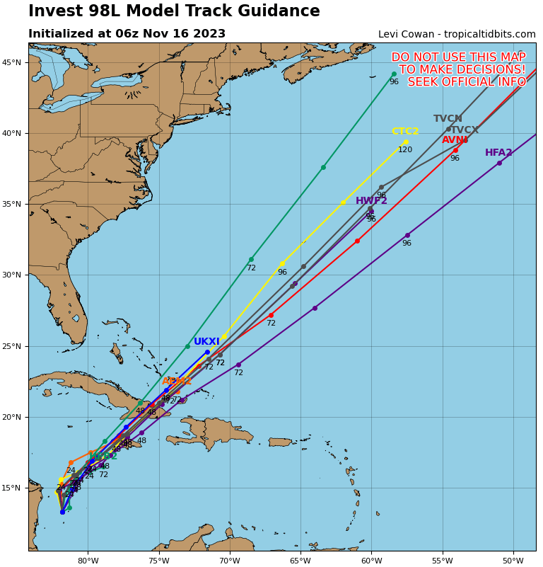
What are they saying about the low that is off of Panama? Heading NE again?
This is from Monday
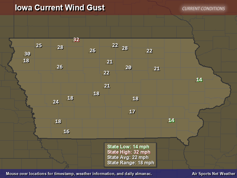
It’s unclear to me from that map whether it sucks or blows in Iowa.
Need the windage indicators that reflect speed and direction.
Thursday is officially the last day of the 2023 Atlantic hurricane season, which ranks as the 4th busiest when it comes to named storms. There were officially 20 named storms and seven hurricanes, three of which were major.
The only hurricane to make landfall in the U.S. this year was Hurricane Idalia, which made landfall near Keaton Beach, Florida, as a category 3, producing 7-12 feet of surge and flooding rain.
Although the season ends today, the Atlantic remains abnormally warm, which will keep chances for some subtropical development possible during the offseason.
One more day and I can start drinking the gallon jugs of hurricane water that I bought earlier in the season.
Ha you too! My garage has two cases of bottled water and I need to use them up.One more day and I can start drinking the gallon jugs of hurricane water that I bought earlier in the season.
https://media.tenor.com/dhyvmM1US8QAAAAM/wtf-what-the-****.gif
I’m over the damn rain. We’ve probably had 7 inches over the last 10 days.

Here too.I’m over the damn rain. We’ve probably had 7 inches over the last 10 days.
That’s what she said.I’m over the damn rain. We’ve probably had 7 inches over the last 10 days.
Flood Watch
National Weather Service Miami FL
126 PM EST Wed Dec 13 2023
FLZ068-072-074-168-172-173-140600-
/O.CON.KMFL.FA.A.0008.000000T0000Z-231215T0000Z/
/00000.0.ER.000000T0000Z.000000T0000Z.000000T0000Z.OO/
Metro Palm Beach County-Metro Broward County-Metropolitan Miami
Dade-Coastal Palm Beach County-Coastal Broward County-Coastal
Miami Dade County-
Including the cities of Pembroke Pines, Deerfield Beach, Sawgrass
Mills Mal, Miramar, Jupiter, Coral Springs, Hollywood, Davie,
Pompano Beach, West Palm Beach, Fort Lauderdale, Sunrise,
Kendall, Boynton Beach, Miami, Palm Beach Gardens, Florida
Gardens, Greenacres City, Riviera Beach, Carol City, Sandalfoot
Cove, Lake Worth, Boca Raton, Hialeah, and Delray Beach
126 PM EST Wed Dec 13 2023
...FLOOD WATCH REMAINS IN EFFECT THROUGH THURSDAY EVENING...
* WHAT...Flooding caused by excessive rainfall continues to be
possible.
* WHERE...A portion of southeast Florida, including the following
areas, Coastal Broward County, Coastal Miami Dade County, Coastal
Palm Beach County, Metro Broward County, Metro Palm Beach County
and Metropolitan Miami Dade.
* WHEN...Through Thursday evening.
* IMPACTS...Flooding may occur in poor drainage and urban areas.
Storm drains and ditches may become clogged with debris.
* ADDITIONAL DETAILS...
- Periods of heavy rain will likely continue through Thursday
evening at the very least. Additional rainfall amounts of 1-3
inches with locally higher amounts will be possible during
this time frame. High rainfall rates along with repeated
bouts of rainfall may result in flooding in urban and poor
drainage areas.
- http://www.weather.gov/safety/flood
PRECAUTIONARY/PREPAREDNESS ACTIONS...
You should monitor later forecasts and be alert for possible Flood
Warnings. Those living in areas prone to flooding should be prepared
to take action should flooding develop.
&&
$$
CWC
Flood Watch
National Weather Service Key West FL
316 PM EST Wed Dec 13 2023
FLZ076>078-141030-
/O.NEW.KKEY.FA.A.0002.231215T0900Z-231217T0900Z/
/00000.0.ER.000000T0000Z.000000T0000Z.000000T0000Z.OO/
Monroe Upper Keys-Monroe Middle Keys-Monroe Lower Keys-
Including the cities of Marathon, Key Largo, and Key West
316 PM EST Wed Dec 13 2023
...FLOOD WATCH IN EFFECT FROM EARLY FRIDAY MORNING THROUGH LATE
SATURDAY NIGHT...
* WHAT...Flooding caused by excessive rainfall is possible.
* WHERE...The Florida Keys.
* WHEN...From early Friday morning through late Saturday night.
* IMPACTS...Flooding may occur in low-lying and poor drainage areas.
* ADDITIONAL DETAILS...
- Heavy rainfall is expected at times early Friday morning
through late Saturday night. Storm totals of 4-8 inches with
locally higher amounts in excess of 10 inches is possible.
High rainfall rates along with repeated bouts of rainfall may
result in flooding of low-lying and poor drainage areas.
- http://www.weather.gov/safety/flood
PRECAUTIONARY/PREPAREDNESS ACTIONS...
You should monitor later forecasts and be alert for possible Flood
Warnings. Those living in areas prone to flooding should be prepared
to take action should flooding develop.
&&
$$
NB
Similar threads
- Replies
- 9
- Views
- 288
- Replies
- 16
- Views
- 435
ADVERTISEMENT
ADVERTISEMENT