Long-range outlook for Irma
Computer model guidance on Irma’s future track made an important westward shift on Sunday night. Virtually all models—including our most reliable ones for hurricane track forecasts, the GFS, European, and UKMET—took Irma further west than prior model runs before an expected sharp turn to the north. This shift increases the chance that Irma will directly affect Hispaniola and especially Cuba, as discussed above. The shift also raises the odds for a U.S. landfall considerably, because Irma’s expected right turn toward the north would probably occur too late for Irma to miss the U.S. East Coast entirely. A strong upper-level trough will be moving well offshore by early next week, reducing the odds that Irma would be hauled out to sea.
It is unclear exactly why the modeled track shifted so dramatically on Sunday night, but the Monday morning (12Z) GFS run is very consistent with this shift, lending support to it. One piece of the puzzle is that the first Hurricane Hunter observations on Irma, gathered Sunday afternoon, were fed into the 00Z Monday runs. A
raft of additional new data will be gathered on Monday and fed into upcoming model runs. This includes observations around Irma’s environment from the NOAA Gulfstream-IV, as well as extra radiosonde launches (weather balloons) that will sample the upper atmosphere at midday Monday (18Z) from 21 locations across the central U.S., where the upper-level trough expected to move offshore late this week will be taking shape. The model runs from 00Z Tuesday
will incorporate the new data, so this will give us a much better sense of the steering currents guiding Irma and how those may evolve over the next week.
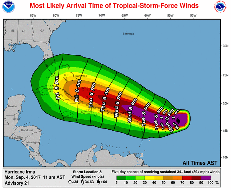
Irma is still four days from any potential direct U.S. impacts, so there is plenty of time for residents along the East Coast and eastern Gulf Coast to make any standard preparations for hurricane season that haven’t yet been squared away. The Sunday night model runs suggest that the entire Florida peninsula will need to pay very close attention to Irma, but it remains possible that Irma will move further north along the East Coast, or it could enter the eastern Gulf of Mexico. There is strong model support for a north-northwest track once Irma makes its major right turn late in the week. The crucial variables will be how long it takes that turn to occur, how sharp the turn is, and whether Irma’s strength has been dented by interactions with Hispaniola and/or Cuba, as noted above.
Bottom line: It is becoming more likely that Irma will move close enough to the northern Leeward Islands, Puerto Rico, Hispaniola, and/or Cuba for significant impacts. There is an increasing chance that Irma will strike the U.S. late in the weekend or early next week, quite possibly as a major hurricane. It is still too soon to predict the location or timing of any U.S. landfall with confidence.
https://www.wunderground.com/cat6/threat-increasing-cuba-florida-intensifying-irma