ADVERTISEMENT

Weather Warning, for Northern Iowa Especially - Possible Derecho Winds!

h-hawk

HR King
Gold Member
Jan 29, 2002
56,217
102,384
113
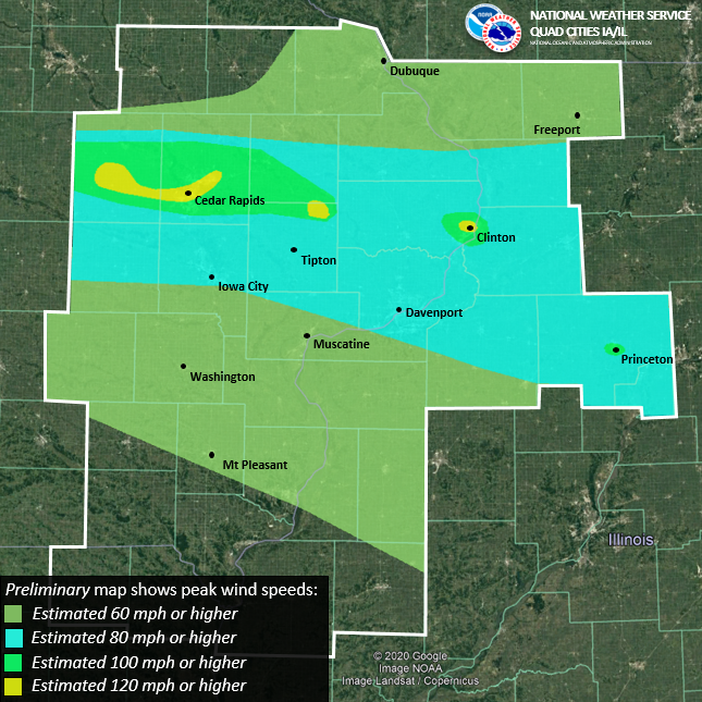
"A cluster of severe thunderstorms is currently tracking through eastern South Dakota and vectoring east-southeast. The Storm Prediction Center has issued a “Moderate Risk” (Level 4 out of 5) within the existing “Enhanced Risk” (Level 3 out of 5) from earlier this morning for northwest Iowa. The line has the potential to be classified as a derecho, so the primary threat is severe straight-line winds in excess of 80 mph. Here is the Day 1 Outlook from the SPC highlighting the highest severe wind potential.

Current modeling has the line entering northwest Iowa later this afternoon and evening and propagating along a warm front draped across northern Iowa. Modeling also shows the complex losing some energy as it reaches north-central Iowa, but this will depend on the stability of the squall line. Please stay updated via local/social media and the NWS. Attached is a Situation Report that highlights severe potential and dangerous heat."

 
Which way should you face to piss this afternoon? Toward Illinois, Nebraska, Missouri, or Minnesota?
 
  • Like
Reactions: jasonrann
No this s**t again.
Is this the new normal? We had ours. Northern Minnesota had a big one a year or two ago. I think there were one or two others the last few years.
 
  • Like
Reactions: anon_b29nm7v7dwp6r
I’m thinking it will just go north of those of us in the corridor….but the video I saw of Huron South Dakota is enough to get me charging all the batteries and going to fill the car with gas.

not catching me unaware this time Mother Nature…
 
  • Like
Reactions: JupiterHawk
Never even heard of this before the actual one. Now they are hyping the small possibility of another.

gotta get those ratings. The old ladies and kwwl meteorologists are giddy.
I don’t get this at all….derechos have been a thing as far as I can remember. I remember the term being used in the 90’s if not before.
 
Live Sioux Falls cam. That is an ominous horizon for sure (and a strange color).


FW7hnPOX0AI6Usq
 
Last edited:
I don’t get this at all….derechos have been a thing as far as I can remember. I remember the term being used in the 90’s if not before.
I watch maybe an hour of TV a day so that probably has something to do with it.
 
Just read the NWS Des Moines and Quad Cities office's narratives.

They're not all that sure this line is going to hold together from a severe perspective because the bow line is outrunning where the best shear (therefore severe potential) is. This means it's moving into areas that aren't as conducive to it retaining strength.

They do believe it will hold together though, and dump copious amounts of rain at least into central Iowa for certain. Appears the line itself will hold together all the way across Iowa, say straddling the US20 corridor and maybe clipping far enough south to near US30.

She'll continue to pack a wallop for awhile, and hopefully bring some much needed rain to the northern half of Iowa at the very least. Might get some more storms developing in its wake too.
 
  • Like
Reactions: JupiterHawk
Based on the watches being issued by NWS this thing may be further south than they were talking about earlier today…
 
  • Like
Reactions: McLovin32
I tell ya what it feels like that day two years ago out there….miserable. Feels like temp was 111 a bit ago on my digital thermometer out there…
edit: not to say it will be like the 2020 event, that was like the storm of the century…not all derechos are the same….just like not all hurricanes are the same…
 
ADVERTISEMENT

Latest posts

ADVERTISEMENT